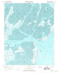
1968 Map of Cobb Island
USGS Topo · Published 1971About this map
Cobb Island and the shifting barrier landscapes of the Virginia Eastern Shore are documented here in the late 1960s. This coastal environment is defined by an intricate network of deep-water routes like Eckichy Channel and Mittigy Channel cutting through expansive tidal flats and salt marshes. The map reveals the isolation of the outer banks, where Wreck Island stands exposed to the Atlantic Ocean south of the Sand Shoal Inlet.
Find a feature on this map
42 named features on this map. Tap any name to fly to it.
Don’t see what you’re looking for? This feature index may not catch every label — zoom into the map to look around manually.
Map Details
Editions of this 1968 Cobb Island Map
4 editions found
Other maps of this area

1941 · Broadwater
USGS Topo · 1:62,500

1942 · Cheriton
USGS Topo · 1:24,000

1942 · Cobb Island
USGS Topo · 1:24,000

1942 · Great Machipongo Inlet
USGS Topo · 1:24,000

1942 · Little Machipongo Inlet
USGS Topo · 1:24,000

1942 · Nassawadox
USGS Topo · 1:24,000

1943 · Nassawadox
USGS Topo · 1:31,680

1943 · Townsend
USGS Topo · 1:24,000

1943 · Franktown
USGS Topo · 1:31,680

1946 · Eastville
USGS Topo · 1:250,000