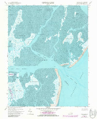
1968 Map of Cobb Island
USGS Topo · Published 1986About this map
Cobb Island and Wreck Island stand as prominent barriers against the Atlantic Ocean in this coastal survey of Northampton County. The map details a complex hydrologic network of tidal flats and marshes, including Man and Boy Marsh and Big Easter Marsh, which are separated by deep-water passages such as the Mittigy Channel and Eckichy Channel. This environment is shaped by shifting sands and seasonal tides, where landforms like Parchaby Tump and Little Cobb Island offer small points of elevation above the water. To the west, the Mockhorn Island State Wildlife Management Area encompasses Mockhorn Island, preserving a significant portion of this fragile ecosystem. The intricate labeling of minor features like Sunday Ditch and Black Perch Cr provides a specialized look at the navigation routes and coastal landmarks used by mariners and locals before later 20th-century environmental changes.
Find a feature on this map
40 named features on this map. Tap any name to fly to it.
Don’t see what you’re looking for? This feature index may not catch every label — zoom into the map to look around manually.
Map Details
Editions of this 1968 Cobb Island Map
4 editions found
Other maps of this area

1941 · Broadwater
USGS Topo · 1:62,500

1942 · Cheriton
USGS Topo · 1:24,000

1942 · Cobb Island
USGS Topo · 1:24,000

1942 · Great Machipongo Inlet
USGS Topo · 1:24,000

1942 · Little Machipongo Inlet
USGS Topo · 1:24,000

1942 · Nassawadox
USGS Topo · 1:24,000

1943 · Nassawadox
USGS Topo · 1:31,680

1943 · Townsend
USGS Topo · 1:24,000

1943 · Franktown
USGS Topo · 1:31,680

1946 · Eastville
USGS Topo · 1:250,000