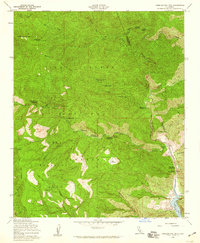
1958 Map of Cobblestone Mtn
USGS Topo · Published 1959About this map
Cobblestone Mtn dominates this mountainous portion of the Los Padres National Forest during the late 1950s, situated along the border of Ventura and Los Angeles Counties. The landscape is defined by deep drainages like Agua Blanca Creek and Piru Creek, which flow toward the newly formed Lake Piru at the southeastern corner. This era of forest management is reflected in the numerous backcountry sites such as Tin Can Cabin Campground, Log Cabin Campground, and the uniquely named Ellis Apiary Campground. High-elevation landmarks like Whiteacre Peak overlook the Sespe Wildlife Area, while topographic curiosities such as The Pothole and the narrow passage at Devils Gateway characterize the remote terrain. Evidence of early settlement and land use persists at the Whitaker Ranch and along the White Mountain Trail, documenting a period when these canyons were primarily accessed by foot, horse, or forest service firebreaks.
Find a feature on this map
53 named features on this map. Tap any name to fly to it.
Don’t see what you’re looking for? This feature index may not catch every label — zoom into the map to look around manually.
Map Details
Editions of this 1958 Cobblestone Mtn Map
3 editions found
Other maps of this area

1900 · Piru
USGS Topo · 1:62,500

1903 · Tejon
USGS Topo · 1:125,000

1903 · Camulos
USGS Topo · 1:125,000

1903 · Santa Susana
USGS Topo · 1:62,500

1921 · Piru
USGS Topo · 1:62,500

1931 · Whitaker Peak
USGS Topo · 1:24,000

1931 · Santa Felicia Canyon
USGS Topo · 1:24,000

1932 · Beartrap Canyon
USGS Topo · 1:24,000

1935 · Santa Felicia Canyon
USGS Topo · 1:24,000

1935 · Whitaker Peak
USGS Topo · 1:24,000