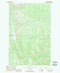
1989 Map of Cody Butte
USGS Topo · Published 1989About this map
The Colville Indian Reservation dominates this 1980s landscape in Ferry County, where the topography is defined by high ridges and a complex network of waterways. High points like Cody Butte are central landmarks, featuring the Lookout Tower Cody Butte as a primary observational post for the surrounding territory. The drainage system is particularly intricate, with the Sanpoil River flowing through the western portion of the quadrangle while numerous named tributaries like Twentythree Mile Creek, North Nanamkin Creek, and Thirtymile Creek carve out deep valleys.
Find a feature on this map
13 named features on this map. Tap any name to fly to it.
Don’t see what you’re looking for? This feature index may not catch every label — zoom into the map to look around manually.
Map Details
Editions of this 1989 Cody Butte Map
2 editions found
Other maps of this area

1950 · Nespelem
USGS Topo · 1:62,500

1952 · Keller
USGS Topo · 1:62,500

1953 · Seventeenmile Mtn.
USGS Topo · 1:62,500

1953 · Bald Knob
USGS Topo · 1:62,500

1954 · Okanogan
USGS Topo · 1:250,000

1958 · Okanogan
USGS Topo · 1:250,000

1984 · Nespelem
USGS Topo · 1:100,000

1986 · Central Peak
USGS Topo · 1:24,000
1989 · Nespelem NE
USGS Topo · 1:24,000
1989 · Seventeenmile Mountain
USGS Topo · 1:24,000