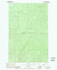
1989 Map of Cody Lake
USGS Topo · Published 1989About this map
The Colville Indian Reservation defines the southeastern portion of this landscape in Ferry County, where the high-altitude terrain is carved by numerous watercourses. Centrally located, Cody Lake sits amidst a network of drainage systems including the headwaters of Lynx Creek and the southern reaches of Twentythree Mile Creek. The map documents a sparsely populated but geographically complex region, characterized by township boundaries such as T 33 N and T 32 N that intersect the reservation's northern edge. Further south, the path of Bridge Creek winds through the protected lands, illustrating the intricate hydrography of the Sanpoil River watershed. This survey, based on 1980s aerial photography, captures the area's transition into the late twentieth century, highlighting the permanence of tribal boundaries and the importance of localized water sources in this upland environment.
Find a feature on this map
7 named features on this map. Tap any name to fly to it.
Don’t see what you’re looking for? This feature index may not catch every label — zoom into the map to look around manually.
Map Details
Editions of this 1989 Cody Lake Map
2 editions found
Other maps of this area

1948 · Wilmont Creek
USGS Topo · 1:62,500

1950 · Wilmont Creek
USGS Topo · 1:62,500

1952 · Keller
USGS Topo · 1:62,500

1952 · Twin Lakes
USGS Topo · 1:62,500

1953 · Seventeenmile Mtn.
USGS Topo · 1:62,500

1954 · Okanogan
USGS Topo · 1:250,000

1956 · Wilmont Creek
USGS Topo · 1:62,500

1958 · Okanogan
USGS Topo · 1:250,000

1984 · Nespelem
USGS Topo · 1:100,000
1985 · Sitdown Mtn
USGS Topo · 1:24,000