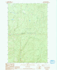
1989 Map of Cody Lake
USGS Topo · Published 1994About this map
The Colville Indian Reservation encompasses much of this 1980s landscape, where high-elevation drainage systems define the geography of Ferry County. Bridge Creek and Lynx Creek carve through the terrain, illustrating the complex hydrology of this interior highland. The presence of the Twentymile Campground near Cody Lake suggests the area’s importance for recreation and forest management during this period. To the south, Thirtymile Creek winds through the reservation, while various Springs and the prominent Cody Butte serve as critical landmarks for navigating the township boundaries of T 33 N and T 32 N. This survey provides a precise record of the land before the late-20th-century shifts in forest access and preservation.
Find a feature on this map
10 named features on this map. Tap any name to fly to it.
Don’t see what you’re looking for? This feature index may not catch every label — zoom into the map to look around manually.
Map Details
Editions of this 1989 Cody Lake Map
2 editions found
Other maps of this area

1948 · Wilmont Creek
USGS Topo · 1:62,500

1950 · Wilmont Creek
USGS Topo · 1:62,500

1952 · Keller
USGS Topo · 1:62,500

1952 · Twin Lakes
USGS Topo · 1:62,500

1953 · Seventeenmile Mtn.
USGS Topo · 1:62,500

1954 · Okanogan
USGS Topo · 1:250,000

1956 · Wilmont Creek
USGS Topo · 1:62,500

1958 · Okanogan
USGS Topo · 1:250,000

1984 · Nespelem
USGS Topo · 1:100,000
1985 · Sitdown Mtn
USGS Topo · 1:24,000