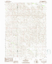
1986 Map of Cody Lake SW
USGS Topo · Published 1986About this map
The remote sandhills of central Nebraska are meticulously detailed in this 1980s provisional survey of the boundary between McPherson and Logan Counties. The landscape is defined by the sweeping drainage of Lone Valley, where the subtle topography of the prairie is punctuated only by a few established homesteads. Isolated outposts such as Oliver Ranch and Lair Ranch represent the primary human presence in this region, illustrating the expansive scale of ranching operations required to navigate this portion of the Great Plains. The map's contour lines and numerous small depressions offer a specialized view of the cattle country's water-holding terrain before more modern developments changed the local infrastructure.
Find a feature on this map
4 named features on this map. Tap any name to fly to it.
Don’t see what you’re looking for? This feature index may not catch every label — zoom into the map to look around manually.
Map Details
Editions of this 1986 Cody Lake SW Map
This is the sole edition of this map. No revisions or reprints were ever made.
Other maps of this area

1899 · North Platte
USGS Topo · 1:125,000

1902 · North Platte
USGS Topo · 1:125,000

1949 · Cody Lake
USGS Topo · 1:62,500

1951 · Tryon
USGS Topo · 1:62,500

1951 · Cody Lake
USGS Topo · 1:62,500

1954 · North Platte
USGS Topo · 1:250,000

1956 · North Platte
USGS Topo · 1:250,000

1957 · North Platte
USGS Topo · 1:250,000

1967 · North Platte
USGS Topo · 1:250,000

1972 · Stapleton NW
USGS Topo · 1:24,000