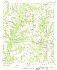
1957 Map of Coffee Springs
USGS Topo · Published 1969About this map
Coffee Springs serves as the primary hub on this mid-century survey of the wiregrass region, situated near the headwaters of Beaverdam Creek. The landscape is defined by an intricate network of drainage, where Double Bridges Creek and Beargrass Creek carve through the terrain. A notable water feature is Geneva County Lake, complete with its spillway elevation noted. This era in South Alabama is characterized by a high density of rural community centers, represented here by numerous churches that also served as burial grounds, such as Holloway Ch, Marvin Chapel, and El Bethel Ch. Small-scale extractive industry is evident through several sand and gravel pits scattered near Central City and Spears. The map documents the political boundary between Coffee County and Geneva County, crossing just north of the Center Ridge Ch area.
Find a feature on this map
37 named features on this map. Tap any name to fly to it.
Don’t see what you’re looking for? This feature index may not catch every label — zoom into the map to look around manually.
Map Details
Editions of this 1957 Coffee Springs Map
Other maps of this area

1942 · Enterprise
USGS Topo · 1:125,000

1950 · Enterprise
USGS Topo · 1:62,500

1953 · Andalusia
USGS Topo · 1:250,000

1953 · Dothan
USGS Topo · 1:250,000

1954 · Dothan
USGS Topo · 1:250,000

1955 · Dothan
USGS Topo · 1:250,000

1957 · Andalusia
USGS Topo · 1:250,000

1957 · Geneva
USGS Topo · 1:62,500

1957 · Bellwood
USGS Topo · 1:24,000
1957 · Geneva West
USGS Topo · 1:24,000