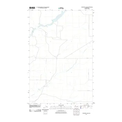
2011 Map of Coffeepot Lake
USGS Topo · Published 2011About this map
Coffeepot Lake dominates the northern reaches of this landscape in Lincoln County, where the hydrology of the Scablands is clearly defined by seasonal watercourses and spring-fed basins. The irregular shoreline of Coffeepot Lake is fed by Lake Creek, which also connects to the smaller Deer Lake. To the south, the drainage pattern shifts toward Duck Creek and its associated Duck Lake.
Find a feature on this map
14 named features on this map. Tap any name to fly to it.
Don’t see what you’re looking for? This feature index may not catch every label — zoom into the map to look around manually.
Map Details
Editions of this 2011 Coffeepot Lake Map
This is the sole edition of this map. No revisions or reprints were ever made.
Other maps of this area

1953 · Ritzville
USGS Topo · 1:250,000

1959 · Ritzville
USGS Topo · 1:250,000

1965 · Ritzville
USGS Topo · 1:250,000

1968 · Sylvan Lake
USGS Topo · 1:24,000

1968 · Coffeepot Lake
USGS Topo · 1:24,000

1968 · Pacific Lake
USGS Topo · 1:24,000
1968 · Odessa
USGS Topo · 1:24,000

1969 · Rocklyn SW
USGS Topo · 1:24,000

1969 · Cormana Lake
USGS Topo · 1:24,000

1969 · Lamona
USGS Topo · 1:24,000