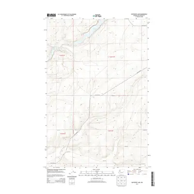
2013 Map of Coffeepot Lake
USGS Topo · Published 2013About this map
Coffeepot Lake and the nearby Coffeepot Spring anchor this portion of the Channeled Scablands in Lincoln County. The landscape is defined by the basaltic coulee formations characteristic of this region, with Deer Lake and Duck Lake filling smaller depressions in the rocky terrain. A network of rural roads, many bearing local family names like Carlson Rd and Hemmering Rd, provides access across the section lines of the Public Land Survey System.
Find a feature on this map
18 named features on this map. Tap any name to fly to it.
Don’t see what you’re looking for? This feature index may not catch every label — zoom into the map to look around manually.
Map Details
Editions of this 2013 Coffeepot Lake Map
This is the sole edition of this map. No revisions or reprints were ever made.
Other maps of this area

1953 · Ritzville
USGS Topo · 1:250,000

1959 · Ritzville
USGS Topo · 1:250,000

1965 · Ritzville
USGS Topo · 1:250,000

1968 · Sylvan Lake
USGS Topo · 1:24,000

1968 · Coffeepot Lake
USGS Topo · 1:24,000

1968 · Pacific Lake
USGS Topo · 1:24,000
1968 · Odessa
USGS Topo · 1:24,000

1969 · Rocklyn SW
USGS Topo · 1:24,000

1969 · Cormana Lake
USGS Topo · 1:24,000

1969 · Lamona
USGS Topo · 1:24,000