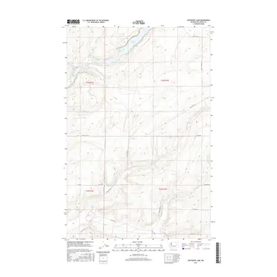
2017 Map of Coffeepot Lake
USGS Topo · Published 2017About this map
Coffeepot Lake and its surrounding basalt-carved landscape define this portion of Lincoln County, where the desert floor is punctuated by seasonal water and vital springs. The 2017 survey details the rural network of the t23n r33e and t23n r34e townships, where access is provided by family-named routes such as Huddle Corner Rd N and Trejbal Back Rd E. The hydrologic pattern of Lake Cr and the smaller Deer Lake reflects the unique geology of the Channeled Scablands. This map is a record of land management and drainage in an arid environment, showing the relationship between small water bodies like Duck Lake and the intermittent flow of Duck Cr. It serves as an essential reference for understanding contemporary land use and historical property boundaries in this sparsely populated region of Washington state.
Find a feature on this map
21 named features on this map. Tap any name to fly to it.
Don’t see what you’re looking for? This feature index may not catch every label — zoom into the map to look around manually.
Map Details
Editions of this 2017 Coffeepot Lake Map
This is the sole edition of this map. No revisions or reprints were ever made.
Other maps of this area

1953 · Ritzville
USGS Topo · 1:250,000

1959 · Ritzville
USGS Topo · 1:250,000

1965 · Ritzville
USGS Topo · 1:250,000

1968 · Sylvan Lake
USGS Topo · 1:24,000

1968 · Coffeepot Lake
USGS Topo · 1:24,000

1968 · Pacific Lake
USGS Topo · 1:24,000
1968 · Odessa
USGS Topo · 1:24,000

1969 · Rocklyn SW
USGS Topo · 1:24,000

1969 · Cormana Lake
USGS Topo · 1:24,000

1969 · Lamona
USGS Topo · 1:24,000