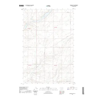
2020 Map of Coffeepot Lake
USGS Topo · Published 2020About this map
Coffeepot Lake dominates the northern reaches of this landscape in Lincoln County, its elongated form fed by Coffeepot Spring. The terrain is defined by the Scablands' distinctive drainage patterns, where Lake Cr and Duck Cr cut through the volcanic basalt plateaus. Rural access is maintained by a network of family-named gravel and dirt routes, such as Huddle Corner Rd N and Kaputa Rd E, reflecting the enduring ranching and agricultural footprint in this portion of eastern Washington. While primarily open range, the presence of smaller water bodies like Deer Lake and Duck Lake provides critical focal points for local land use and hydrology within the townships of t23n r34e and t22n r33e.
Find a feature on this map
21 named features on this map. Tap any name to fly to it.
Don’t see what you’re looking for? This feature index may not catch every label — zoom into the map to look around manually.
Map Details
Editions of this 2020 Coffeepot Lake Map
This is the sole edition of this map. No revisions or reprints were ever made.
Other maps of this area

1953 · Ritzville
USGS Topo · 1:250,000

1959 · Ritzville
USGS Topo · 1:250,000

1965 · Ritzville
USGS Topo · 1:250,000

1968 · Sylvan Lake
USGS Topo · 1:24,000

1968 · Coffeepot Lake
USGS Topo · 1:24,000

1968 · Pacific Lake
USGS Topo · 1:24,000
1968 · Odessa
USGS Topo · 1:24,000

1969 · Rocklyn SW
USGS Topo · 1:24,000

1969 · Cormana Lake
USGS Topo · 1:24,000

1969 · Lamona
USGS Topo · 1:24,000