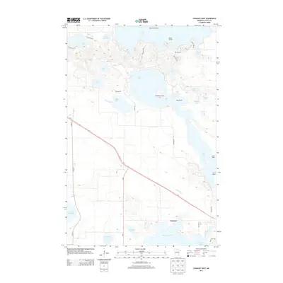
2013 Map of Cohasset West
USGS Topo · Published 2013About this map
Cohasset serves as the primary settlement in this river-and-lake landscape of Itasca County, situated at a junction where Us-2 meets the winding Mississippi River. The terrain is defined by an intricate network of glacial lakes, including the expansive Deer Lake to the north and the hydrologically connected Blackwater Lake and Jay Gould Lake to the south. Local landmarks like Battleship Island, Picnic Island, and Hog Island rise from the water, suggesting a history of seasonal recreation and navigation. This survey demonstrates the modern transportation footprint of the early 21st century, showing how roads like MN-6 and Co HWY-11 segment the wetlands. Smaller water bodies such as Lillian Lake and Warburg Lake are scattered throughout the interior, while Stevens Brook and Blackwater Cr provide natural drainage through the low-lying basin toward the river valley.
Find a feature on this map
42 named features on this map. Tap any name to fly to it.
Don’t see what you’re looking for? This feature index may not catch every label — zoom into the map to look around manually.
Map Details
Editions of this 2013 Cohasset West Map
This is the sole edition of this map. No revisions or reprints were ever made.
Other maps of this area

1953 · Cohasset East
USGS Topo · 1:24,000

1953 · Siseebakwet Lake
USGS Topo · 1:24,000

1953 · Cohasset West
USGS Topo · 1:24,000

1953 · Grand Rapids
USGS Topo · 1:24,000

1954 · Hibbing
USGS Topo · 1:250,000

1957 · Hibbing
USGS Topo · 1:250,000

1958 · Hibbing
USGS Topo · 1:250,000

1964 · Hibbing
USGS Topo · 1:250,000

1970 · Deer River NE
USGS Topo · 1:24,000

1970 · Wabana Lake
USGS Topo · 1:24,000