
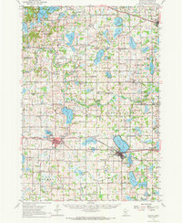
1958 Map of Cokato
USGS Topo · Published 1959About this map
Cokato and Howard Lake anchor this 1950s landscape of the central Minnesota lake country, where established townships like Stockholm and Middleville reveal a dense network of ethnic and community foundations. The map is a remarkable record of rural social centers, documenting dozens of localized institutions such as the Finnish Ch, Norwegian Ch, and the St Ignatius Cem. This era shows the region's educational infrastructure still largely intact at the township level, with schools like Happy Corner Sch and Lee Sch serving dispersed farmsteads.
Find a feature on this map
116 named features on this map. Tap any name to fly to it.
Don’t see what you’re looking for? This feature index may not catch every label — zoom into the map to look around manually.
Map Details
Editions of this 1958 Cokato Map
2 editions found
Other maps of this area

1951 · Annandale
USGS Topo · 1:62,500

1953 · Saint Paul
USGS Topo · 1:250,000

1953 · New Ulm
USGS Topo · 1:250,000

1953 · Saint Cloud
USGS Topo · 1:250,000

1953 · Stillwater
USGS Topo · 1:250,000

1955 · Stillwater
USGS Topo · 1:250,000

1957 · Saint Cloud
USGS Topo · 1:250,000

1957 · New Ulm
USGS Topo · 1:250,000

1957 · Waconia
USGS Topo · 1:62,500

1958 · New Ulm
USGS Topo · 1:250,000