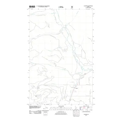
2011 Map of Colburn
USGS Topo · Published 2011About this map
Colburn and the surrounding Idaho panhandle landscape are defined by the winding course of the Pack River and its numerous mountain tributaries. This 2011 survey illustrates a transition from the alpine slopes of the Schweitzer Basin Ski Area and Colburn Day Lodge in the southwest to the rural valley floors near Woodside. The drainage network is dense, with Hellroaring Creek, Caribou Creek, and Berry Creek cutting through the forested terrain. The map's detail of the road system, including Old Mill Rd and Natl Forest Develop Road 2611, reflects the region's legacy of timber management and modern recreation. These corridors provide a clear record of how the valley has been accessed for both industry and mountain sports at the start of the twenty-first century.
Find a feature on this map
37 named features on this map. Tap any name to fly to it.
Don’t see what you’re looking for? This feature index may not catch every label — zoom into the map to look around manually.
Map Details
Editions of this 2011 Colburn Map
This is the sole edition of this map. No revisions or reprints were ever made.
Other maps of this area

1901 · Sandpoint
USGS Topo · 1:125,000

1911 · Priest Lake
USGS Topo · 1:250,000

1911 · Sandpoint
USGS Topo · 1:125,000

1913 · Priest Lake
USGS Topo · 1:250,000

1951 · Elmira
USGS Topo · 1:62,500

1958 · Sandpoint
USGS Topo · 1:250,000

1963 · Sandpoint
USGS Topo · 1:250,000

1965 · Naples
USGS Topo · 1:24,000

1967 · Mount Roothaan
USGS Topo · 1:24,000
1967 · Dodge Peak
USGS Topo · 1:24,000