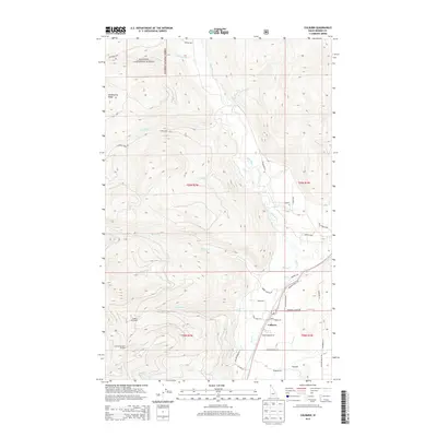
2013 Map of Colburn
USGS Topo · Published 2013About this map
Colburn sits at the heart of this North Idaho landscape, where the valley floor meets the steep ascent of the Selkirk Mountains. The terrain is defined by the drainage of the Pack River and its numerous tributaries, including Sand Cr and French Cr, which cut through the dense timber of the Kanisku National Forest. Along the western edge of the quadrangle, the high-elevation recreation of the Schweitzer Basin Ski Area is visible, including the Colburn Day Lodge. This 2013 survey illustrates the local road network connecting the settlement at Colburn to residential pockets like Woodside and Norway Lodge Hts. A mix of forestry roads like NFD Road 2431 and rural lanes such as Oliver Creek Rd reveals the modern balance between industrial timber management, mountain tourism, and rural Idaho living.
Find a feature on this map
46 named features on this map. Tap any name to fly to it.
Don’t see what you’re looking for? This feature index may not catch every label — zoom into the map to look around manually.
Map Details
Editions of this 2013 Colburn Map
This is the sole edition of this map. No revisions or reprints were ever made.
Other maps of this area

1901 · Sandpoint
USGS Topo · 1:125,000

1911 · Priest Lake
USGS Topo · 1:250,000

1911 · Sandpoint
USGS Topo · 1:125,000

1913 · Priest Lake
USGS Topo · 1:250,000

1951 · Elmira
USGS Topo · 1:62,500

1958 · Sandpoint
USGS Topo · 1:250,000

1963 · Sandpoint
USGS Topo · 1:250,000

1965 · Naples
USGS Topo · 1:24,000

1967 · Mount Roothaan
USGS Topo · 1:24,000
1967 · Dodge Peak
USGS Topo · 1:24,000