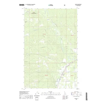
2020 Map of Colburn
USGS Topo · Published 2020About this map
Colburn serves as the primary settlement hub in this northern Idaho landscape, situated where the Pack River valley meets the eastern foothills of the Selkirk Mountains. The map reveals a complex interface between managed timberlands and residential development, with the Kaniksu National Forest covering the high, northern terrain dominated by Hellroaring Ridge. The drainage network of Colburn Creek, Caribou Creek, and French Creek carves through the topography, supporting both natural ecosystems and recreational access via routes like the French Creek A Ohv and French Creek B Ohv trails. Local infrastructure is concentrated in the south, where roads such as Norway Lodge Heights Road and Sand Creek Parkway reflect the area's modern connectivity. This survey captures a balance of industrial forest use, highland wilderness, and the rural residential growth typical of the Bonner County interior during the early 21st century.
Find a feature on this map
53 named features on this map. Tap any name to fly to it.
Don’t see what you’re looking for? This feature index may not catch every label — zoom into the map to look around manually.
Map Details
Editions of this 2020 Colburn Map
This is the sole edition of this map. No revisions or reprints were ever made.
Other maps of this area

1901 · Sandpoint
USGS Topo · 1:125,000

1911 · Priest Lake
USGS Topo · 1:250,000

1911 · Sandpoint
USGS Topo · 1:125,000

1913 · Priest Lake
USGS Topo · 1:250,000

1951 · Elmira
USGS Topo · 1:62,500

1958 · Sandpoint
USGS Topo · 1:250,000

1963 · Sandpoint
USGS Topo · 1:250,000

1965 · Naples
USGS Topo · 1:24,000

1967 · Mount Roothaan
USGS Topo · 1:24,000
1967 · Dodge Peak
USGS Topo · 1:24,000