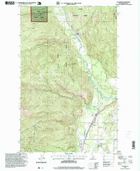
1996 Map of Colburn
USGS Topo · Published 1999About this map
Pack River meanders through the central valley of this northern Idaho landscape, dividing the steep mountain terrain of the Kaniksu National Forest from the developed lowlands near Colburn. The settlement of Colburn serves as a focal point for the region's infrastructure, situated near several distinct recreational and industrial sites. To the west, the high-elevation slopes of Hellroaring Ridge lead toward the Schweitzer Basin Ski Area, where the Colburn Day Lodge marks the upper reaches of the drainage. The valley floor reflects a mix of modern land use and essential services, featuring both a Stock Car Race Track and the Woodside Motorcross Race Track, alongside utility sites like a Gaging Sta and a Sanitary Land Fill. Numerous drainages including Hellroaring Creek, Caribou Creek, and Berry Creek feed into the main river system, illustrating the complex watershed of the Idaho Panhandle in the late twentieth century.
Find a feature on this map
20 named features on this map. Tap any name to fly to it.
Don’t see what you’re looking for? This feature index may not catch every label — zoom into the map to look around manually.
Map Details
Editions of this 1996 Colburn Map
This is the sole edition of this map. No revisions or reprints were ever made.
Other maps of this area

1901 · Sandpoint
USGS Topo · 1:125,000

1911 · Priest Lake
USGS Topo · 1:250,000

1911 · Sandpoint
USGS Topo · 1:125,000

1913 · Priest Lake
USGS Topo · 1:250,000

1951 · Elmira
USGS Topo · 1:62,500

1958 · Sandpoint
USGS Topo · 1:250,000

1963 · Sandpoint
USGS Topo · 1:250,000

1965 · Naples
USGS Topo · 1:24,000

1967 · Mount Roothaan
USGS Topo · 1:24,000
1967 · Dodge Peak
USGS Topo · 1:24,000