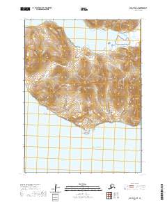
2020 Map of Cold Bay A-2 SE
USGS Topo · Published 2020About this map
King Cove and the surrounding coastline of the Alaska Peninsula define this 2020 landscape, where the terrestrial terrain meets the Pacific Ocean. The geography is shaped by steep volcanic slopes and coastal markers such as Vodapoin Point and Morgan Point, which overlook the waters of Deer Passage. A single primary artery, the King Cove Access Road, provides the only overland connection through the northern portion of the map, skirting the base of the mountains.
Find a feature on this map
14 named features on this map. Tap any name to fly to it.
Don’t see what you’re looking for? This feature index may not catch every label — zoom into the map to look around manually.
Map Details
Editions of this 2020 Cold Bay A-2 SE Map
This is the sole edition of this map. No revisions or reprints were ever made.
Other maps of this area

1943 · Fort Randall
USGS Topo · 1:250,000

1949 · False Pass
USGS Topo · 1:250,000

1949 · Fort Randall
USGS Topo · 1:250,000

1950 · False Pass
USGS Topo · 1:250,000

1950 · Fort Randall
USGS Topo · 1:250,000

1963 · False Pass D-1
USGS Topo · 1:63,360

1963 · False Pass D-2
USGS Topo · 1:63,360
1983 · Cold Bay A-1
USGS Topo · 1:63,360
1995 · Cold Bay A-2
USGS Topo · 1:63,360
2020 · False Pass D-1 NW
USGS Topo · 1:25,000