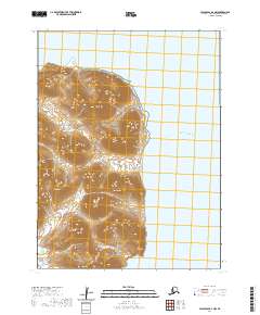
2020 Map of False Pass D-1 NW
USGS Topo · Published 2020About this map
Deer Island and the complex northern shoreline of the Alaska Peninsula dominate this survey of the Aleutians East region. The landscape is defined by steep coastal elevations rising sharply from the Pacific Ocean and the narrow waters of Deer Passage. This terrain is dissected by short, high-gradient drainage systems like Eastern Cr and Southern Cr, which flow toward the eastern coast from the interior highlands. Near the northern limit of the sheet, Stag Point serves as a prominent maritime landmark where the coastline turns sharply. The lack of roads or established settlements emphasizes the wilderness character of the area, typical of the remote Unimak Island vicinity where surveying relies on SPOT satellite imagery and modern hydrography data.
Find a feature on this map
10 named features on this map. Tap any name to fly to it.
Don’t see what you’re looking for? This feature index may not catch every label — zoom into the map to look around manually.
Map Details
Editions of this 2020 False Pass D-1 NW Map
This is the sole edition of this map. No revisions or reprints were ever made.
Other maps of this area

1943 · Fort Randall
USGS Topo · 1:250,000

1949 · False Pass
USGS Topo · 1:250,000

1949 · Fort Randall
USGS Topo · 1:250,000

1950 · False Pass
USGS Topo · 1:250,000

1950 · Fort Randall
USGS Topo · 1:250,000

1963 · False Pass D-1
USGS Topo · 1:63,360

1963 · False Pass D-2
USGS Topo · 1:63,360
1983 · Cold Bay A-1
USGS Topo · 1:63,360
1995 · Cold Bay A-2
USGS Topo · 1:63,360
2020 · False Pass D-1 NE
USGS Topo · 1:25,000