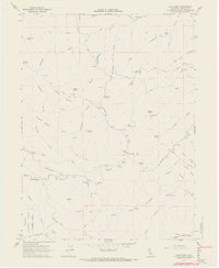
1967 Map of Cold Fork
USGS Topo · Published 1968About this map
Skinner Mill Place and other family-named homesteads anchor this 1960s landscape in Tehama County, where the foothills meet the Trinity National Forest. The map documents a rugged interior network of gulches and creeks, including the drainage of the Cold Fork and South Fork Cottonwood Creek. Settlement is sparse and largely centered on flats suitable for grazing or early mountain industry, as seen at Alford Place and Pettyjohn Place. Local history is preserved in small but significant markers like the Graves near Oak Flat and the evocative naming of Hole in the Ground and Shakecabin Flat. The terrain is defined by dramatic peaks such as Stevenson Peak and the curiously named Stinking Springs, illustrating how early residents navigated and labeled this isolated stretch of the California range.
Find a feature on this map
58 named features on this map. Tap any name to fly to it.
Don’t see what you’re looking for? This feature index may not catch every label — zoom into the map to look around manually.
Map Details
Editions of this 1967 Cold Fork Map
3 editions found
Other maps of this area

1890 · Red Bluff
USGS Topo · 1:250,000

1894 · Red Bluff
USGS Topo · 1:250,000

1949 · Colyear Springs
USGS Topo · 1:62,500

1951 · Chanchelulla Peak
USGS Topo · 1:62,500

1952 · Ono
USGS Topo · 1:62,500

1954 · Yolla Bolly
USGS Topo · 1:62,500

1957 · Colyear Springs
USGS Topo · 1:62,500

1958 · Redding
USGS Topo · 1:250,000
1967 · Cold Fork
USGS Topo · 1:24,000
1967 · Oxbow Bridge
USGS Topo · 1:24,000