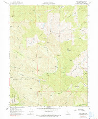
1967 Map of Cold Fork
USGS Topo · Published 1990About this map
Trinity National Forest boundaries mark the southwestern corner of this 1960s terrain, where the headwaters of the South Fork and Cottonwood Creek weave through a network of ridges and flats. The landscape is dotted with small-scale agrarian and industrial history, evidenced by Skinner Mill Place and numerous family-named locations such as Alford Place, Pettyjohn Place, and Haven Place. These settlements are often situated on small level openings in the topography like Schoolhouse Flat or Wakefield Flat.
Find a feature on this map
52 named features on this map. Tap any name to fly to it.
Don’t see what you’re looking for? This feature index may not catch every label — zoom into the map to look around manually.
Map Details
Editions of this 1967 Cold Fork Map
3 editions found
Other maps of this area

1890 · Red Bluff
USGS Topo · 1:250,000

1894 · Red Bluff
USGS Topo · 1:250,000

1949 · Colyear Springs
USGS Topo · 1:62,500

1951 · Chanchelulla Peak
USGS Topo · 1:62,500

1952 · Ono
USGS Topo · 1:62,500

1954 · Yolla Bolly
USGS Topo · 1:62,500

1957 · Colyear Springs
USGS Topo · 1:62,500

1958 · Redding
USGS Topo · 1:250,000
1967 · Cold Fork
USGS Topo · 1:24,000
1967 · Oxbow Bridge
USGS Topo · 1:24,000