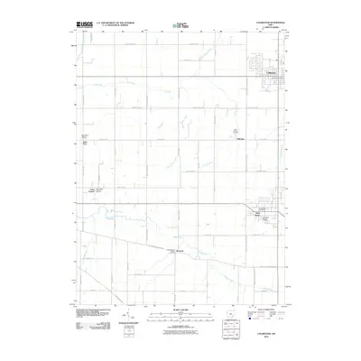
2010 Map of Coldwater
USGS Topo · Published 2010About this map
Coldwater and Saint Henry anchor this corner of Mercer County, reflecting a landscape defined by small crossroads settlements and a strong Catholic heritage. The distribution of communities such as Saint Peter, Saint Joseph, Philothea, and Wendelin — each often centered around a namesake cemetery or church site — illustrates the early 20th-century social structure of rural Ohio. The Wabash River meanders through the southern half of the quadrangle, joined by a network of drainage systems including Little Beaver Creek, Toti Creek, and Big Run. This grid-heavy landscape is interconnected by a dense web of local roads like Fort Recovery Minster Rd and Burkettsville Saint Henry Rd, tracing the boundaries of family farmsteads that have shaped the region's agricultural character for generations.
Find a feature on this map
50 named features on this map. Tap any name to fly to it.
Don’t see what you’re looking for? This feature index may not catch every label — zoom into the map to look around manually.
Map Details
Editions of this 2010 Coldwater Map
This is the sole edition of this map. No revisions or reprints were ever made.
Other maps of this area

1908 · St. Henry
USGS Topo · 1:62,500

1911 · Berne
USGS Topo · 1:48,000

1914 · Celina
USGS Topo · 1:62,500

1915 · Fort Recovery
USGS Topo · 1:48,000

1918 · Fort Recovery
USGS Topo · 1:62,500

1944 · Celina
USGS Topo · 1:62,500

1953 · Muncie
USGS Topo · 1:250,000

1956 · Muncie
USGS Topo · 1:250,000

1960 · Fort Recovery
USGS Topo · 1:24,000
1960 · Celina
USGS Topo · 1:24,000