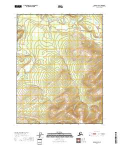
2018 Map of Coleen A-1 SW
USGS Topo · Published 2018About this map
Salmon Trout River meanders across the northern reaches of this remote Alaskan interior, carving a distinct valley floor that contrasts with the surrounding high-elevation ridgelines. As a part of the U.S. Geological Survey 2018 US Topo series, the sheet documents the complex topography of the Yukon-Koyukuk Census Area with 40-foot contour intervals. The landscape is defined by its dramatic relief and the absence of human infrastructure, focusing instead on the hydrological patterns and township and range boundaries like t26n r29e and t27n r28e that divide the wilderness. This modern survey provides researchers a precise look at the drainage patterns and land-division grids in a region where the natural water systems remain the primary geographic landmarks.
Find a feature on this map
7 named features on this map. Tap any name to fly to it.
Don’t see what you’re looking for? This feature index may not catch every label — zoom into the map to look around manually.
Map Details
Editions of this 2018 Coleen A-1 SW Map
This is the sole edition of this map. No revisions or reprints were ever made.
Other maps of this area

1951 · Black River
USGS Topo · 1:250,000

1951 · Coleen
USGS Topo · 1:250,000

1956 · Coleen
USGS Topo · 1:250,000

1956 · Coleen A-1
USGS Topo · 1:63,360

1956 · Black River D-2
USGS Topo · 1:63,360
1956 · Black River D-1
USGS Topo · 1:63,360

1956 · Coleen A-2
USGS Topo · 1:63,360

1956 · Black River
USGS Topo · 1:250,000

1964 · Black River
USGS Topo · 1:250,000
2018 · Coleen A-2 SE
USGS Topo · 1:25,000