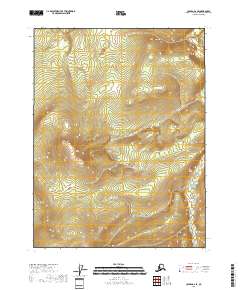
2018 Map of Coleen A-2 SE
USGS Topo · Published 2018About this map
This high-altitude landscape in the Yukon-Koyukuk Census Area is defined by its dramatic topographic relief and remote northern character. The survey covers several major township divisions including T26n R27e and T26n R28e, where steep ridgelines and deep drainage basins are meticulously charted. Without established roads or named settlements, the map focuses on the physical geography of the Alaskan interior, showing a complex network of seasonal watercourses and high summits that climb above 2,200 feet. The detailed contour intervals provided by the U.S. Geological Survey illustrate the sharp transitions between valley floors and the towering ridges of T27n R27e and T25n R28e. For the naturalist or cartographic researcher, this sheet offers a precise view of the untouched wilderness in a region where human infrastructure has not yet left a permanent mark.
Find a feature on this map
6 named features on this map. Tap any name to fly to it.
Don’t see what you’re looking for? This feature index may not catch every label — zoom into the map to look around manually.
Map Details
Editions of this 2018 Coleen A-2 SE Map
This is the sole edition of this map. No revisions or reprints were ever made.
Other maps of this area

1951 · Black River
USGS Topo · 1:250,000

1951 · Coleen
USGS Topo · 1:250,000

1956 · Coleen
USGS Topo · 1:250,000

1956 · Coleen A-1
USGS Topo · 1:63,360

1956 · Black River D-2
USGS Topo · 1:63,360
1956 · Black River D-1
USGS Topo · 1:63,360

1956 · Coleen A-2
USGS Topo · 1:63,360

1956 · Black River
USGS Topo · 1:250,000

1964 · Black River
USGS Topo · 1:250,000
2018 · Coleen A-2 NW
USGS Topo · 1:25,000