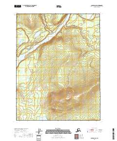
2018 Map of Coleen A-3 SW
USGS Topo · Published 2018About this map
The Porcupine River flows through this expansive interior landscape, joined by the Coleen River as it winds through the northern reaches of the Yukon-Koyukuk region. This 2018 survey illustrates a wilderness defined by water and elevation, where the drainage of Fish Cr and numerous smaller channels carve through the terrain. The map provides a precise layout of the Public Land Survey System grid, including boundaries for t27n r24e and t26n r24e, which are essential for locating specific wilderness tracts or historical land claims. Free of modern settlements or road networks, the area remains a study in natural hydrography and undeveloped subarctic geography near the international border.
Find a feature on this map
9 named features on this map. Tap any name to fly to it.
Don’t see what you’re looking for? This feature index may not catch every label — zoom into the map to look around manually.
Map Details
Editions of this 2018 Coleen A-3 SW Map
This is the sole edition of this map. No revisions or reprints were ever made.
Other maps of this area

1951 · Black River
USGS Topo · 1:250,000

1951 · Coleen
USGS Topo · 1:250,000

1956 · Coleen
USGS Topo · 1:250,000

1956 · Black River D-3
USGS Topo · 1:63,360

1956 · Black River D-4
USGS Topo · 1:63,360

1956 · Coleen A-3
USGS Topo · 1:63,360

1956 · Coleen A-4
USGS Topo · 1:63,360

1956 · Black River
USGS Topo · 1:250,000

1964 · Black River
USGS Topo · 1:250,000
2018 · Black River D-3 NE
USGS Topo · 1:25,000