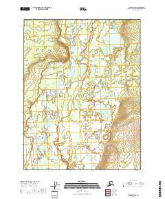
2018 Map of Coleen B-4 SW
USGS Topo · Published 2018About this map
The Coleen River defines the landscape of this remote Yukon-Koyukuk region, winding through a complex system of braided channels and riparian wetlands. Flowing southward, the river is the central geographical feature within the townships of t29n r21e, t29n r22e, and t28n r22e. The terrain is characterized by a low-lying river valley punctuated by subtle topographic rises, particularly in the northeast and southeast sectors of the quadrangle. Grayling Cr joins the larger drainage network from the west, contributing to a wilderness environment largely devoid of human infrastructure or permanent settlements at this time. This 2018 survey illustrates the natural hydrology and land divisions typical of northern Alaska, where the vastness of the river system dictates the local geography.
Find a feature on this map
6 named features on this map. Tap any name to fly to it.
Don’t see what you’re looking for? This feature index may not catch every label — zoom into the map to look around manually.
Map Details
Editions of this 2018 Coleen B-4 SW Map
This is the sole edition of this map. No revisions or reprints were ever made.
Other maps of this area

1951 · Coleen
USGS Topo · 1:250,000

1956 · Coleen
USGS Topo · 1:250,000

1956 · Coleen A-5
USGS Topo · 1:63,360

1956 · Coleen A-4
USGS Topo · 1:63,360
1990 · Coleen B-5
USGS Topo · 1:63,360
1990 · Coleen B-4
USGS Topo · 1:63,360
2018 · Coleen A-4 NE
USGS Topo · 1:25,000
2018 · Coleen B-5 NE
USGS Topo · 1:25,000
2018 · Coleen B-4 SE
USGS Topo · 1:25,000
2018 · Coleen A-4 NW
USGS Topo · 1:25,000