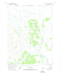
1972 Map of Coleen D-4
USGS Topo · Published 1974About this map
The North Boundary Fairbanks Meridian cuts across the northern reaches of this Alaskan interior terrain, a landscape defined by an intricate network of waterways and high-elevation relief. Mapping conducted in the early 1970s via photogrammetric methods captures the untouched hydrology of the region, where Joanna Creek and Patricia Creek wind through deep valleys. This area remains distinctly wild, lacking roads or permanent settlements at the time of the survey. The presence of Khayyam Creek and the smaller Omar Cr indicates a drainage system that feeds into larger basins, while a significant unnamed Pass suggests a natural transit corridor between the peaks. This 1972 data provides a baseline for the northern Yukon territory before modern environmental changes, emphasizing the remote character of the Fairbanks Meridian borderlands.
Find a feature on this map
6 named features on this map. Tap any name to fly to it.
Don’t see what you’re looking for? This feature index may not catch every label — zoom into the map to look around manually.
Map Details
Editions of this 1972 Coleen D-4 Map
This is the sole edition of this map. No revisions or reprints were ever made.
Other maps of this area

1951 · Coleen
USGS Topo · 1:250,000

1951 · Table Mountain
USGS Topo · 1:250,000

1956 · Table Mountain
USGS Topo · 1:250,000

1956 · Coleen
USGS Topo · 1:250,000

1964 · Table Mountain
USGS Topo · 1:250,000
1972 · Coleen D-5
USGS Topo · 1:63,360
1972 · Table Mountain A-4
USGS Topo · 1:63,360
1972 · Coleen D-3
USGS Topo · 1:63,360
1972 · Table Mountain A-3
USGS Topo · 1:63,360
1990 · Coleen C-4
USGS Topo · 1:63,360