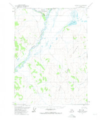
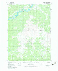
1972 Map of Coleen D-5
USGS Topo · Published 1974About this map
The Sheenjek River meanders through this portion of the Arctic National Wildlife Range, creating a complex network of braided channels and seasonal swamps. This 1972 survey, based on aerial photography, documents the untouched wilderness of the Brooks Range foothills before modern developments. The topography is dominated by the massive profile of Seven Dikes Mountain, which rises east of the river valley. Numerous water bodies like Grayling Lake and small tributaries such as Joanna Creek, Patricia Creek, and Monument Creek are detailed throughout the terrain. This map captures a landscape defined by natural drainage patterns and unpopulated territory, serving as a baseline for environmental study and historical wilderness research in Northern Alaska.
Find a feature on this map
8 named features on this map. Tap any name to fly to it.
Don’t see what you’re looking for? This feature index may not catch every label — zoom into the map to look around manually.
Map Details
Editions of this 1972 Coleen D-5 Map
This is the sole edition of this map. No revisions or reprints were ever made.
Other maps of this area

1951 · Coleen
USGS Topo · 1:250,000

1951 · Table Mountain
USGS Topo · 1:250,000

1956 · Table Mountain
USGS Topo · 1:250,000

1956 · Coleen
USGS Topo · 1:250,000

1964 · Table Mountain
USGS Topo · 1:250,000
1972 · Coleen D-4
USGS Topo · 1:63,360
1972 · Table Mountain A-5
USGS Topo · 1:63,360
1972 · Table Mountain A-4
USGS Topo · 1:63,360

1972 · Coleen D-6
USGS Topo · 1:63,360
1983 · Coleen C-6
USGS Topo · 1:63,360