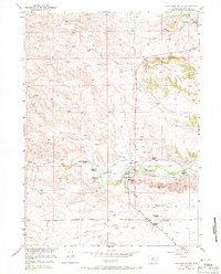
1950 Map of Coleman Butte
USGS Topo · Published 1971About this map
Coleman Butte and the surrounding high plains of Platte County define this landscape as it appeared at the mid-century. The map meticulously documents a ranching-based economy, centered on family-held operations such as the Harry Coleman Ranch, M L Coleman Ranch, and the H B Coleman Ranch located near the Cottonwood Community Hall. This concentration of namesake landmarks suggests a significant local family history and a tight-knit community structure typical of Wyoming's agricultural regions during the late 1940s field checks.
Find a feature on this map
22 named features on this map. Tap any name to fly to it.
Don’t see what you’re looking for? This feature index may not catch every label — zoom into the map to look around manually.
Map Details
Editions of this 1950 Coleman Butte Map
3 editions found
Other maps of this area

1896 · Hartville
USGS Topo · 1:125,000

1901 · Hartville
USGS Topo · 1:125,000

1949 · Spring Creek
USGS Topo · 1:24,000

1950 · Spring Creek
USGS Topo · 1:24,000

1950 · Coleman Butte
USGS Topo · 1:24,000

1950 · Herman Ranch
USGS Topo · 1:24,000

1950 · Cottonwood Falls
USGS Topo · 1:24,000

1951 · Coleman Butte
USGS Topo · 1:24,000

1951 · Sibley Peak
USGS Topo · 1:24,000

1951 · Cottonwood Falls
USGS Topo · 1:24,000