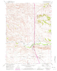
1950 Map of Coleman Butte
USGS Topo · Published 1982About this map
The Coleman Butte vicinity in Platte County was defined by a network of family-owned ranching operations during the mid-20th century. This 1950 survey, which was updated with aerial revisions in the late 1970s, illustrates a landscape where life centered around the Cottonwood Community Hall and several homesteads along the local watercourses. The drainage of Cottonwood Creek and Crow Creek provided the necessary irrigation and water supply for properties such as the Adams Ranch, Willadsen Ranch, and the H B Coleman Ranch.
Find a feature on this map
21 named features on this map. Tap any name to fly to it.
Don’t see what you’re looking for? This feature index may not catch every label — zoom into the map to look around manually.
Map Details
Editions of this 1950 Coleman Butte Map
3 editions found
Other maps of this area

1896 · Hartville
USGS Topo · 1:125,000

1901 · Hartville
USGS Topo · 1:125,000

1949 · Spring Creek
USGS Topo · 1:24,000

1950 · Spring Creek
USGS Topo · 1:24,000

1950 · Coleman Butte
USGS Topo · 1:24,000

1950 · Herman Ranch
USGS Topo · 1:24,000

1950 · Cottonwood Falls
USGS Topo · 1:24,000

1951 · Coleman Butte
USGS Topo · 1:24,000

1951 · Sibley Peak
USGS Topo · 1:24,000

1951 · Cottonwood Falls
USGS Topo · 1:24,000