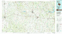
1985 Map of Coleman
USGS Topo · Published 1994About this map
The Colorado River and Concho River converge in the southwest corner of this West Texas landscape, a region defined by its wide ranchlands and the sudden rise of the Holloway Mountains. Centered on the hub of Coleman, the map illustrates a network of small, scattered cattle and farming communities like Trickham, Gouldbusk, and Valera that rely on the vital water of Pecan Bayou and Hords Creek. The eastern edge is anchored by the recreational expanse of Lake Brownwood State Park, while the transportation corridor of the At & SF RR runs parallel to US Highway 67, cutting a path toward Santa Anna. Isolated peaks such as Indian Mountain and Bead Mountain serve as prominent landmarks across the plains, marking a terrain where legacy ranching and local aviation at the Municipal Airport shaped the mid-to-late 20th-century economy.
Find a feature on this map
69 named features on this map. Tap any name to fly to it.
Don’t see what you’re looking for? This feature index may not catch every label — zoom into the map to look around manually.
Map Details
Editions of this 1985 Coleman Map
2 editions found
Other maps of this area

1885 · San Saba
USGS Topo · 1:125,000

1887 · Coleman
USGS Topo · 1:125,000

1889 · Brownwood
USGS Topo · 1:125,000

1889 · Coleman
USGS Topo · 1:125,000

1890 · Abilene
USGS Topo · 1:125,000

1891 · Hayrick
USGS Topo · 1:125,000

1892 · San Angelo
USGS Topo · 1:125,000

1892 · Eden
USGS Topo · 1:125,000

1892 · Abilene
USGS Topo · 1:125,000

1892 · Ballinger
USGS Topo · 1:125,000