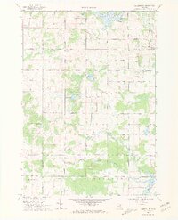
1969 Map of Coleman NE
USGS Topo · Published 1972About this map
Wiggins Lake and the winding course of the North Branch Tobacco River dominate this central Michigan landscape in the late 1960s. The map illustrates a rural area defined by its water bodies and section-line roads, with the Clare Co Gladwin Co line dividing the townships. Local community life is anchored at West Grout Ch and the Grout Cem, while a Lookout Tower sits near the junction of Buzzell Road and Mc Culloch Road. To the south, the terrain follows the Middle Branch Tobacco River toward Ross Lake, showing evidence of resource extraction through scattered Oil Wells and Gravel Pits. This survey captures the transition of the land from natural timber and water resources to a grid-based agricultural and industrial landscape.
Find a feature on this map
41 named features on this map. Tap any name to fly to it.
Don’t see what you’re looking for? This feature index may not catch every label — zoom into the map to look around manually.
Map Details
Editions of this 1969 Coleman NE Map
3 editions found
Other maps of this area

1954 · Traverse City
USGS Topo · 1:250,000

1954 · Midland
USGS Topo · 1:250,000

1958 · Traverse City
USGS Topo · 1:250,000

1958 · Midland
USGS Topo · 1:250,000

1959 · Midland
USGS Topo · 1:250,000

1966 · Midland
USGS Topo · 1:250,000

1969 · Wagarville
USGS Topo · 1:24,000

1969 · Meredith SW
USGS Topo · 1:24,000

1969 · Gladwin
USGS Topo · 1:24,000

1969 · Coleman
USGS Topo · 1:24,000