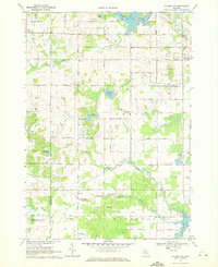
1969 Map of Coleman NE
USGS Topo · Published 1972About this map
The North Branch Tobacco River and Middle Branch Tobacco River converge in this section of Gladwin County, defining a landscape of low-lying wetlands and scattered small lakes. In the late 1960s, the rural character of Grout and Beaverton townships is marked by a precise grid of country roads, including Kerswill Road and Plank Road, which navigate around numerous water bodies like Big Lake Twenty and Kerswill Lake.
Find a feature on this map
44 named features on this map. Tap any name to fly to it.
Don’t see what you’re looking for? This feature index may not catch every label — zoom into the map to look around manually.
Map Details
Editions of this 1969 Coleman NE Map
3 editions found
Other maps of this area

1954 · Traverse City
USGS Topo · 1:250,000

1954 · Midland
USGS Topo · 1:250,000

1958 · Traverse City
USGS Topo · 1:250,000

1958 · Midland
USGS Topo · 1:250,000

1959 · Midland
USGS Topo · 1:250,000

1966 · Midland
USGS Topo · 1:250,000

1969 · Wagarville
USGS Topo · 1:24,000

1969 · Meredith SW
USGS Topo · 1:24,000

1969 · Gladwin
USGS Topo · 1:24,000

1969 · Coleman
USGS Topo · 1:24,000