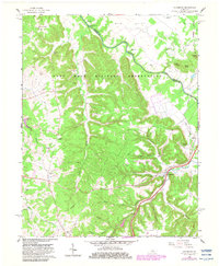
1960 Map of Colesburg
USGS Topo · Published 1983About this map
The Fort Knox Military Reservation dominates this landscape along the border of Bullitt and Hardin Counties, where the winding course of the Rolling Fork carves through the terrain. The settlement of Colesburg serves as a local anchor near the Louisville and Nashville rail line, which follows the natural corridor of Clear Run. This mid-century survey, with photorevisions from the early 1980s, reveals a high density of small family and community burial grounds, including Hagan Cem, Daugherty Cem, and Patterson Chapel Cem, suggesting a long history of rural habitation before the military expansion. Notable landmarks like the Woolridge Ferry Bridge and Sycamore Ch provide specific points for genealogical research and local history. The map also details several knobs and high points, such as Potlick Point and Bolton Knob, which overlook the complex drainage systems of Cedar Creek and Mud Run.
Find a feature on this map
47 named features on this map. Tap any name to fly to it.
Don’t see what you’re looking for? This feature index may not catch every label — zoom into the map to look around manually.
Map Details
Editions of this 1960 Colesburg Map
3 editions found
Other maps of this area

1935 · Elizabethtown
USGS Topo · 1:48,000

1936 · Vine Grove
USGS Topo · 1:62,500

1938 · Elizabethtown
USGS Topo · 1:62,500

1943 · Vine Grove
USGS Topo · 1:62,500

1946 · Pitts Point
USGS Topo · 1:24,000

1946 · Fort Knox
USGS Topo · 1:24,000

1946 · Colesburg
USGS Topo · 1:24,000

1946 · Vine Grove
USGS Topo · 1:24,000

1946 · Vine Grove
USGS Topo · 1:62,500

1948 · Cecilia
USGS Topo · 1:24,000