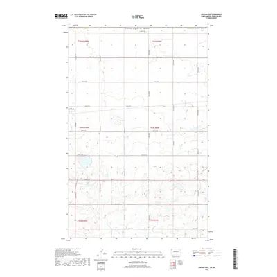
2017 Map of Colgan East
USGS Topo · Published 2017About this map
Colgan sits in the northwestern corner of this prairie landscape, reflecting the grid-based settlement patterns of Divide County near the Canadian border. The terrain is defined by a dense network of sectional roads and thousands of small glacial depressions and wetlands that dot the township lines of t164n r100w and t163n r99w. The east-west corridor of ND 5 serves as the primary artery for the region, connecting isolated farmsteads via a precise matrix of numbered routes like 106th St NW and 135th Ave NW. This survey documents the modern land management and public land survey system divisions in a remote agricultural environment, showing how the rural infrastructure adapts to the undulating, water-pocked geography of the northern plains.
Find a feature on this map
28 named features on this map. Tap any name to fly to it.
Don’t see what you’re looking for? This feature index may not catch every label — zoom into the map to look around manually.
Map Details
Editions of this 2017 Colgan East Map
This is the sole edition of this map. No revisions or reprints were ever made.
Other maps of this area

1948 · Crosby SW
USGS Topo · 1:24,000

1948 · Ambrose
USGS Topo · 1:24,000

1950 · Crosby
USGS Topo · 1:62,500

1953 · Williston
USGS Topo · 1:250,000

1957 · Williston
USGS Topo · 1:250,000

1983 · Colgan West
USGS Topo · 1:24,000

1983 · Alexandria
USGS Topo · 1:24,000
1983 · Colgan East
USGS Topo · 1:24,000
1983 · Colgan SE
USGS Topo · 1:24,000

1984 · Crosby
USGS Topo · 1:100,000