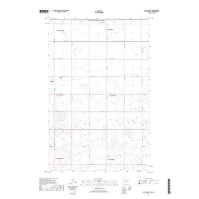
2020 Map of Colgan East
USGS Topo · Published 2020About this map
The settlement of Colgan occupies the northwestern corner of this prairie landscape, situated near the intersection of 106th St NW and 135th Ave NW. This Divide County survey illustrates the rural grid system that defines the region's agricultural character, with long stretches of gravel roads like 130th Ave NW and 109th St NW spanning the township lines. For genealogists and local historians, the Zion Lutheran Cem stands as a significant landmark just east of the village center, providing a fixed point for tracing early residents of the area. The map shows the terrain punctuated by numerous small wetlands and depressions common in this part of North Dakota, crossed only by a few arterial routes such as ND 5 and Co 2. The survey covers the northern boundary of the United States Of America, showing the transition between several townships including t164n r100w and t163n r99w.
Find a feature on this map
29 named features on this map. Tap any name to fly to it.
Don’t see what you’re looking for? This feature index may not catch every label — zoom into the map to look around manually.
Map Details
Editions of this 2020 Colgan East Map
This is the sole edition of this map. No revisions or reprints were ever made.
Other maps of this area

1948 · Crosby SW
USGS Topo · 1:24,000

1948 · Ambrose
USGS Topo · 1:24,000

1950 · Crosby
USGS Topo · 1:62,500

1953 · Williston
USGS Topo · 1:250,000

1957 · Williston
USGS Topo · 1:250,000

1983 · Colgan West
USGS Topo · 1:24,000

1983 · Alexandria
USGS Topo · 1:24,000
1983 · Colgan East
USGS Topo · 1:24,000
1983 · Colgan SE
USGS Topo · 1:24,000

1984 · Crosby
USGS Topo · 1:100,000