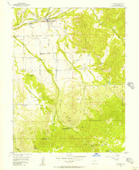
1955 Map of Collbran
USGS Topo · Published 1957About this map
Collbran and Plateau City anchor this 1955 survey of the Plateau Valley, where agricultural life followed the complex irrigation network of the Updyke and Berthold Ditch and Landon Ditch. The landscape is defined by the massive rising shoulders of Kansas Mesa and the Peninsula Plateau, which hem in the drainage of Buzzard Creek. Local history is deeply etched into the terrain through family-named sites like Eagalite Cem and several rural schoolhouses, including the Parker Basin Sch (Aband). To the south, the map climbs toward the Grand Mesa National Forest boundary, a high-country transition marked by the Twin Peaks Bible and Missionary Camp and the isolated peaks of Old Man Mountain and Bald Mountain. The dense contour lines illustrate the dramatic elevation shifts between the valley floor and these forested highlands.
Find a feature on this map
55 named features on this map. Tap any name to fly to it.
Don’t see what you’re looking for? This feature index may not catch every label — zoom into the map to look around manually.
Map Details
Editions of this 1955 Collbran Map
5 editions found
Other maps of this area

1929 · Grand Valley
USGS Topo · 1:62,500

1955 · Collbran
USGS Topo · 1:24,000

1955 · Grand Mesa
USGS Topo · 1:24,000

1955 · Molina
USGS Topo · 1:24,000

1955 · Skyway
USGS Topo · 1:24,000

1955 · The Meadows
USGS Topo · 1:24,000

1956 · Grand Junction
USGS Topo · 1:250,000

1957 · Leadville
USGS Topo · 1:250,000

1959 · Grand Junction
USGS Topo · 1:250,000

1959 · Leadville
USGS Topo · 1:250,000