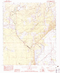
1982 Map of Collinston West
USGS Topo · Published 1983About this map
The Monroe Gas Field dominates the central landscape of this Morehouse and Ouachita Parish border region, reflecting the significant energy infrastructure of the early 1980s. The meandering Boeuf River and Little Bayou Boeuf carve through a terrain characterized by extensive wetland brakes and sloughs, such as Wham Brake and Dewdrop Brake. Transportation corridors are defined by the Arkansas and Louisiana Missouri and Missouri Pacific railroads, which connect rural settlements like Spyker and Upland.
Find a feature on this map
35 named features on this map. Tap any name to fly to it.
Don’t see what you’re looking for? This feature index may not catch every label — zoom into the map to look around manually.
Map Details
Editions of this 1982 Collinston West Map
This is the sole edition of this map. No revisions or reprints were ever made.
Other maps of this area

1935 · Collinston
USGS Topo · 1:62,500

1935 · Naff
USGS Topo · 1:62,500

1935 · Drew
USGS Topo · 1:62,500

1935 · Haile
USGS Topo · 1:62,500

1955 · Jackson
USGS Topo · 1:250,000

1955 · Shreveport
USGS Topo · 1:250,000

1956 · Shreveport
USGS Topo · 1:250,000

1956 · Bastrop
USGS Topo · 1:62,500

1956 · Haile
USGS Topo · 1:62,500

1957 · Monroe North
USGS Topo · 1:62,500