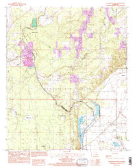
1994 Map of Collinston West
USGS Topo · Published 1995About this map
The Monroe Gas Field dominates the subterranean and surface character of this Morehouse Parish landscape, as documented in the mid-1990s. The terrain is defined by an intricate network of waterways and swampy lowlands, including the broad Wham Brake and the winding course of Bayou Boeuf. These wetlands are punctuated by isolated settlements and family-named landmarks that speak to the region's agricultural and industrial history. Along the southern edge, the Fairbanks Lookout Tower stands as a sentinel over the wooded brakes and gas infrastructure.
Find a feature on this map
31 named features on this map. Tap any name to fly to it.
Don’t see what you’re looking for? This feature index may not catch every label — zoom into the map to look around manually.
Map Details
Editions of this 1994 Collinston West Map
This is the sole edition of this map. No revisions or reprints were ever made.
Other maps of this area

1935 · Collinston
USGS Topo · 1:62,500

1935 · Naff
USGS Topo · 1:62,500

1935 · Drew
USGS Topo · 1:62,500

1935 · Haile
USGS Topo · 1:62,500

1955 · Jackson
USGS Topo · 1:250,000

1955 · Shreveport
USGS Topo · 1:250,000

1956 · Shreveport
USGS Topo · 1:250,000

1956 · Bastrop
USGS Topo · 1:62,500

1956 · Haile
USGS Topo · 1:62,500

1957 · Monroe North
USGS Topo · 1:62,500