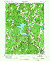
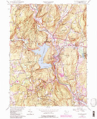
1956 Map of Collinsville
USGS Topo · Published 1966About this map
Nepaug Reservoir dominates the central landscape of this mid-century survey, its expansive waters held by the Phelps Dam and flooding what was once the valley of the Nepaug River. This water management system serves the growing industrial and residential needs of the Farmington Valley during the postwar era. Along the Farmington River, the historic mill village of Collinsville remains a dense cluster of development, contrasted by the more dispersed settlements of Canton Center and Pine Meadow. To the south, the village of Unionville sits at the bend of the river, marking a significant transition into the town of Burlington. Evidence of early travel and recreation is found in the Tunxis Trail and the Washington Turnpike, while numerous burial grounds such as Greenwood Cem and Town Hill Cem provide essential data points for local genealogists.
Find a feature on this map
79 named features on this map. Tap any name to fly to it.
Don’t see what you’re looking for? This feature index may not catch every label — zoom into the map to look around manually.
Map Details
Editions of this 1956 Collinsville Map
5 editions found
Other maps of this area

1892 · Winsted
USGS Topo · 1:62,500

1892 · Meriden
USGS Topo · 1:62,500

1892 · Granby
USGS Topo · 1:62,500

1893 · Waterbury
USGS Topo · 1:62,500

1893 · Meriden
USGS Topo · 1:62,500

1904 · Waterbury
USGS Topo · 1:62,500

1904 · Litchfield
USGS Topo · 1:125,000

1906 · Farmington
USGS Topo · 1:125,000
1946 · New Britain
USGS Topo · 1:31,680

1946 · Bristol
USGS Topo · 1:31,680