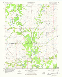
1959 Map of Collinsville NE
USGS Topo · Published 1977About this map
The winding course of the Caney River dictates the landscape of this northeastern Oklahoma region, carving through the jurisdictional boundaries of Washington, Rogers, and Tulsa counties. During the late 1950s, the area maintained a balance between traditional rural life and active extraction industries, evidenced by the numerous Oil Wells and a prominent Strip Mine in the Oolagah district. Small clusters of community life are anchored by landmarks like Rabb Creek Ch and Zion Hill Ch, while the rail corridor of the Atchison Topeka and Santa Fe provides a straight line of transit through the undulating terrain. Local movement follows the water, with Lacy Creek and Horsepen Creek feeding into the river system. The map also records early industrial sites like Claypit and the small settlement at Bevan, capturing the rural infrastructure of the era.
Find a feature on this map
30 named features on this map. Tap any name to fly to it.
Don’t see what you’re looking for? This feature index may not catch every label — zoom into the map to look around manually.
Map Details
Editions of this 1959 Collinsville NE Map
3 editions found
Other maps of this area

1901 · Claremore
USGS Topo · 1:125,000

1901 · Nowata
USGS Topo · 1:125,000

1914 · Nowata
USGS Topo · 1:125,000

1914 · Claremore
USGS Topo · 1:125,000

1916 · Claremore
USGS Topo · 1:125,000

1954 · Tulsa
USGS Topo · 1:250,000

1955 · Sperry
USGS Topo · 1:24,000

1956 · Collinsville
USGS Topo · 1:24,000

1958 · Tulsa
USGS Topo · 1:250,000

1959 · Collinsville NE
USGS Topo · 1:24,000