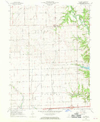
1968 Map of Collison
USGS Topo · Published 1970About this map
The Middle Fork Vermilion River carves through the eastern portion of this Vermilion County landscape, defining the topography between the townships of Pilot, Blount, and Oakwood. In the late 1960s, the area remained deeply rooted in its rural foundations, evidenced by a high density of small family and community burial grounds including Higginsville Cem, Porter Cem, and Emberry Cem. The village of Collison serves as a central point for the northern prairie, while the Chicago and Eastern Illinois railroad corridor cuts across the southern reach toward Newtown. Significant land use is marked by the Kickapoo State Park in the southeast corner, where the terrain shifts from open farmland to the wooded breaks near Glenburn. Genealogists will find particular value in the precisely marked schoolhouse at Newtown Sch and the numerous rural churches like Hebron Ch that anchored these farming communities.
Find a feature on this map
36 named features on this map. Tap any name to fly to it.
Don’t see what you’re looking for? This feature index may not catch every label — zoom into the map to look around manually.
Map Details
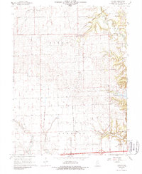
Editions of this 1968 Collison Map
2 editions found
Other maps of this area

1899 · Danville
USGS Topo · 1:62,500

1900 · Danville
USGS Topo · 1:62,500

1931 · Fithian
USGS Topo · 1:48,000

1933 · Hoopeston
USGS Topo · 1:48,000

1936 · Potomac
USGS Topo · 1:62,500

1938 · Hoopeston
USGS Topo · 1:62,500

1943 · Fithian
USGS Topo · 1:62,500

1948 · Danville NW
USGS Topo · 1:24,000

1949 · Danville SW
USGS Topo · 1:24,000

1950 · Danville SW
USGS Topo · 1:24,000