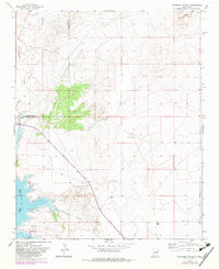
1966 Map of Colorado Canyon
USGS Topo · Published 1983About this map
Sumner Lake and its northern shoreline define the southwestern portion of this topographic survey, marking the transition from the high plains into the drainage of the Pecos River system. The landscape is characterized by deep erosional features like Colorado Canyon and seasonal watercourses such as Alamogordo Creek and Arroyo Potrillo, which carve through the high desert. The survey captures the pastoral isolation of the mid-1960s, documenting family-held lands such as McRee Ranch and Head Ranch. The boundary between Guadalupe and De Baca counties bisects the northern half of the sheet, where cattle tanks and windmills provide the only structural landmarks across the mesas. The inclusion of Sumner Lake State Park illustrates the mid-century development of water resources and recreation in this arid region of east-central New Mexico.
Find a feature on this map
9 named features on this map. Tap any name to fly to it.
Don’t see what you’re looking for? This feature index may not catch every label — zoom into the map to look around manually.
Map Details
Editions of this 1966 Colorado Canyon Map
2 editions found
Other maps of this area

1954 · Fort Sumner
USGS Topo · 1:250,000

1958 · Fort Sumner
USGS Topo · 1:250,000

1964 · Canada Colorado
USGS Topo · 1:24,000

1964 · Fallon Ranch
USGS Topo · 1:24,000

1965 · Windmill Draw
USGS Topo · 1:24,000

1966 · Gibbons Ranch
USGS Topo · 1:24,000

1966 · Alamogordo Dam
USGS Topo · 1:24,000

1966 · Colorado Canyon
USGS Topo · 1:24,000

1968 · Twin Mesa NW
USGS Topo · 1:24,000

1968 · Twin Mesa
USGS Topo · 1:24,000