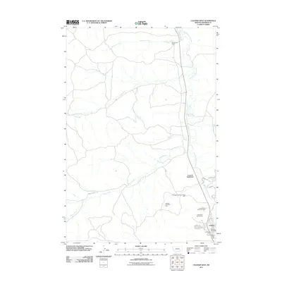
2011 Map of Colstrip West
USGS Topo · Published 2011About this map
Colstrip serves as the focal point of this Eastern Montana landscape, defined by an intricate network of water management and residential development. The southeastern corner of the quadrangle reveals the town's core, featuring the Colstrip Post Office, the Colstrip Fire Dist, and the Ponderosa Butte Public Golf Course. The local geography is heavily influenced by industrial water needs, evidenced by a series of significant structures including the Colstrip Evaporation Pond Dam, Colstrip Diversion Dam, and the Castle Rock Reservoir Dam situated along the East Fork Armells Creek.
Find a feature on this map
25 named features on this map. Tap any name to fly to it.
Don’t see what you’re looking for? This feature index may not catch every label — zoom into the map to look around manually.
Map Details
Editions of this 2011 Colstrip West Map
This is the sole edition of this map. No revisions or reprints were ever made.
Other maps of this area
1954 · Hardin
USGS Topo · 1:250,000
1954 · Forsyth
USGS Topo · 1:250,000
1957 · Hardin
USGS Topo · 1:250,000
1957 · Forsyth
USGS Topo · 1:250,000
1958 · Forsyth
USGS Topo · 1:250,000
1958 · Hardin
USGS Topo · 1:250,000
1971 · Trail Creek School
USGS Topo · 1:24,000
1971 · Colstrip SW
USGS Topo · 1:24,000
1971 · Colstrip SE
USGS Topo · 1:24,000
1971 · Rough Draw
USGS Topo · 1:24,000