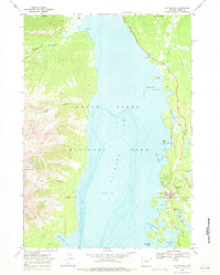
1968 Map of Colter Bay
USGS Topo · Published 1971About this map
Jackson Lake dominates this 1960s study of the Grand Teton National Park shoreline, revealing the concentration of mid-century recreational infrastructure along its eastern banks. The development at Colter Bay Village serves as the focal point, featuring a complex of facilities including an Amphitheater, Campground, and Visitor Center. Further north, Leeks Lodge and a Patrol Cabin near Berry Creek mark the limit of established outposts before the terrain rises sharply into the Teton Range. The western shore is defined by deep, glacially-carved incisions like Webb Canyon, Colter Canyon, and Waterfalls Canyon, which contains the Columbine Cascade. This map illustrates the intersection of intensive park management and wild landscapes, documenting the specific placement of Sewage Disposal Ponds and a network of trails, including the Hermitage Trail, during the peak of the park's modernization era.
Find a feature on this map
41 named features on this map. Tap any name to fly to it.
Don’t see what you’re looking for? This feature index may not catch every label — zoom into the map to look around manually.
Map Details
Editions of this 1968 Colter Bay Map
2 editions found
Other maps of this area

1886 · Shoshone
USGS Topo · 1:125,000

1888 · Shoshone
USGS Topo · 1:125,000

1895 · Shoshone
USGS Topo · 1:125,000

1899 · Grand Teton
USGS Topo · 1:125,000

1901 · Shoshone
USGS Topo · 1:125,000

1901 · Grand Teton
USGS Topo · 1:125,000

1908 · Shoshone
USGS Topo · 1:125,000

1911 · Shoshone
USGS Topo · 1:125,000

1955 · Ashton
USGS Topo · 1:250,000

1955 · Driggs
USGS Topo · 1:250,000