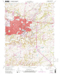
1967 Map of Columbia
USGS Topo · Published 1982About this map
The University of Missouri campus anchors this mid-century view of Columbia, showing the city’s dense institutional core alongside the expanding residential and industrial fringes of Boone County. The map details a sophisticated education and research infrastructure, from Stephens College and Columbia College to the specialized Nuclear Reactor facility and University Hospital. Beyond the urban grid, the landscape is defined by the winding paths of Hinkson Creek and Bear Creek, while the Norfolk and Western railway traces a corridor through the heart of the city. To the south, the transition from urban development to protected natural space is marked by the sprawling terrain of Rock Bridge Memorial State Park, which preserves the karst topography and wooded bluffs above Gans Creek. Small rural landmarks like Little Bonne Femme Ch and Antioch Cem provide essential data points for local history and genealogy.
Find a feature on this map
54 named features on this map. Tap any name to fly to it.
Don’t see what you’re looking for? This feature index may not catch every label — zoom into the map to look around manually.
Map Details
Editions of this 1967 Columbia Map
4 editions found
Other maps of this area

1886 · Jefferson City
USGS Topo · 1:125,000

1890 · Moberly
USGS Topo · 1:125,000

1894 · Jefferson City
USGS Topo · 1:125,000

1917 · Sturgeon
USGS Topo · 1:62,500

1935 · Columbia
USGS Topo · 1:24,000

1940 · Columbia
USGS Topo · 1:24,000

1944 · Millersburg
USGS Topo · 1:62,500

1945 · Centralia
USGS Topo · 1:62,500

1946 · Millersburg
USGS Topo · 1:62,500

1947 · Jefferson City
USGS Topo · 1:250,000