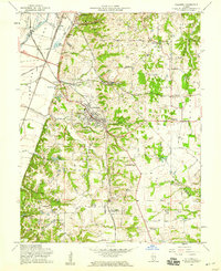
1954 Map of Columbia
USGS Topo · Published 1959About this map
St. Clair and Monroe counties meet along the dramatic bluffs of Sugarloaf, where the flat plains of the American Bottoms give way to upland terrain. This mid-century landscape is defined by its deep-rooted German-American settlements and a complex transportation network, including the Gulf Mobile and Ohio and Missouri Pacific railroads. Columbia serves as the central hub, supported by outlying hamlets like New Hanover and Bixby.
Find a feature on this map
57 named features on this map. Tap any name to fly to it.
Don’t see what you’re looking for? This feature index may not catch every label — zoom into the map to look around manually.
Map Details
Editions of this 1954 Columbia Map
This is the sole edition of this map. No revisions or reprints were ever made.
Other maps of this area

1888 · St. Louis
USGS Topo · 1:62,500

1910 · Waterloo
USGS Topo · 1:62,500

1912 · Kimmswick
USGS Topo · 1:62,500

1913 · Waterloo
USGS Topo · 1:62,500

1916 · Kimmswick
USGS Topo · 1:62,500

1931 · French Village
USGS Topo · 1:24,000

1933 · Jefferson Barracks
USGS Topo · 1:24,000

1933 · Cahokia
USGS Topo · 1:24,000

1934 · Cahokia
USGS Topo · 1:24,000

1935 · French Village
USGS Topo · 1:24,000