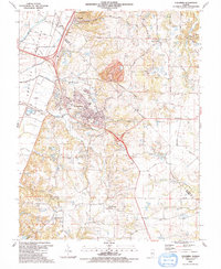
1991 Map of Columbia
USGS Topo · Published 1991About this map
Sugarloaf Hill rises above the low-lying American Bottoms, defining the transition between the Mississippi River floodplain and the higher bluffs of Monroe County. In the early 1990s, this area shows a mix of industrial activity and growing residential clusters, centered on the city of Columbia. Industrial footprints are prominent at the Cement Hollow Oil Field and the large Quarry just north of town, while the complex rail network featuring the Gulf Mobile and Ohio Railroad and the Illinois Central Gulf Railroad underscores the region's historical role as a transit corridor toward St. Louis. Rural life remains anchored by family and community landmarks such as St Pauls Ch, Bethany United Ch, and numerous small burial grounds like Kleinschmidt Cem and Oklahoma Cem. The map traces the winding paths of Carr Creek and Palmer Creek as they drain the bluff lands toward the alluvial plains to the west.
Find a feature on this map
73 named features on this map. Tap any name to fly to it.
Don’t see what you’re looking for? This feature index may not catch every label — zoom into the map to look around manually.
Map Details
Editions of this 1991 Columbia Map
This is the sole edition of this map. No revisions or reprints were ever made.
Other maps of this area

1888 · St. Louis
USGS Topo · 1:62,500

1910 · Waterloo
USGS Topo · 1:62,500

1912 · Kimmswick
USGS Topo · 1:62,500

1913 · Waterloo
USGS Topo · 1:62,500

1916 · Kimmswick
USGS Topo · 1:62,500

1931 · French Village
USGS Topo · 1:24,000

1933 · Jefferson Barracks
USGS Topo · 1:24,000

1933 · Cahokia
USGS Topo · 1:24,000

1934 · Cahokia
USGS Topo · 1:24,000

1935 · French Village
USGS Topo · 1:24,000