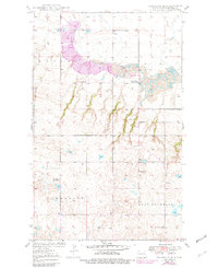
1949 Map of Columbus SE
USGS Topo · Published 1982About this map
Leaf Mountain rises over the high plains of Burke County in this mid-century survey, which reveals the transition from a traditional agrarian township structure to an industrial landscape. The northern sections are dominated by extensive Strip Mine operations and the Coal Valley School No 3, signaling the importance of lignite mining to the local economy. In contrast, the southern portion of the map, spanning the townships of Keller and Harmonious, maintains a rural character defined by a network of local schools and country churches. Genealogists can locate family landmarks such as the St Olaf Cem and Bethany Ch, while the inclusion of the Town Hall and multiple numbered schoolhouses, including Grandview School No 1, illustrates the civic infrastructure of this North Dakota prairie community before late-20th-century consolidation.
Find a feature on this map
15 named features on this map. Tap any name to fly to it.
Don’t see what you’re looking for? This feature index may not catch every label — zoom into the map to look around manually.
Map Details
Editions of this 1949 Columbus SE Map
2 editions found
Other maps of this area

1947 · Columbus
USGS Topo · 1:24,000

1948 · Beaver Lake
USGS Topo · 1:24,000

1948 · Stampede
USGS Topo · 1:24,000

1949 · Columbus SW
USGS Topo · 1:24,000

1949 · Atcoal
USGS Topo · 1:24,000

1949 · Columbus
USGS Topo · 1:24,000

1949 · Columbus SE
USGS Topo · 1:24,000

1950 · Columbus
USGS Topo · 1:62,500

1950 · Portal
USGS Topo · 1:62,500

1953 · Williston
USGS Topo · 1:250,000